


02: Interpreting the System
Between The Lines - Ch 01: Profiles
It is fair enough that we know how the currents interact with the coastline and structure. But let us look at why all this matters.
Although there is no real scientific basis for the following it does seem to be a reasonable explanation that will nonetheless get you to the right place, and hopefully be there at the right time.
The accepted way of finding fish is with electronics, generally including GPS, sounder and temperature gauge. The GPS tells you where you’ve been, where you are and where you are going. The sounder tells you what was under the boat as most of the screen is historical, only the information on the start of where the scrolling image begins is current. The temperature gauge tells you the current temperature.
The way it works is the GPS gives you information that allows you to return to where fish are likely to be because you have come in contact with fish in that location before, or because research of charts or SST maps or simply getting the marks from a contact. The speed log on the GPS will also tell you if there is any current and how fast it is going.
The sounder further enhances your fish finding ability by showing the bottom structure and bait schools. By learning how to use your sounder properly it may also show individual predators and thermoclines.
The temperature gauge is possibly the most important of the tools used as it indicates more than any other where the fish are likely to be as it indicates where the waters of the different zones and currents are mixing.
All these electronic aids certainly help us find fish, but by no means are they the most important. If you consider that nearly all electronics are based on historical information, i.e. a sounder tells you what has been or is under the boat, a GPs tells you past, current and future positions, a temperature gauge tells you the temperatures you have been through. Pete, at this point you say they are not important but in the previous paragraph, you said the temp gauge is the most important.
None of these tells you where you should be, they only tell you where you have been. There are many such as local reports, SST images, what happened and where yesterday etc.
Oceans are in continual flux, every part of your adventure is in new water and it is what is going on where you are when you are there, not even what happened in the immediate past. What is most important to analyse is what is going on right now. The most important skills to do this with are your own senses, primarily your eyes. As you become more experienced, other senses such as smell and feel come into play. You’ll be able to smell sweet oily smells of baitfish oil slicks that tell of recent action upwind. You’ll be able to feel what the current is doing by the way your boat reacts on turns and in certain directions.
For now, we’ll concentrate on training the eyes, as these are the most important in deciding where you should be and then using electronics to back up your findings and help in returning you to the spot.
To get us in a general frame of mind we have to set up some sort of list of preferences as to what are the most important signs that we can expect to work with and where you would expect to find them. Indeed once you are able to find any of the signs the rest are generally in the same general area.
The fish we are seeking can be grouped as predators, but in reality, just about every species in the oceans are predators, each feeding on other creatures. They all have one thing in common: that they will all try and make getting a good feed as easily as possible.
 |
 |
 |
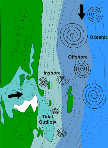
As the currents smash into each other they cause the nutrients to come to the surface where sunlight interacts to help algae grow quickly.Juvenile fish feed on the algae and in turn the chain of predication continues up the line to the larger predators we seek. Our best indication of these corridors is temperature change. The greater the temperature changes over the shortest distance the greater the concentration of life in this corridor.
The other aspect of this is those small bait fishes are unable to travel through temperature changes and associated salinity and oxygen levels easily. Larger predators take advantage of this “wall” to herd baitfish more easily than in the open ocean.
When these currents interact with the shoreline and other structures such as reef, canyons, ridges these factors intensify to narrow the corridors and intensify the temperature differences. Indeed this is such an effective place for a predator they often take up residence on structures and wait for the currents to bring food to them. Note that the predators here include many of the species we call baitfish.
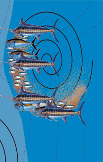
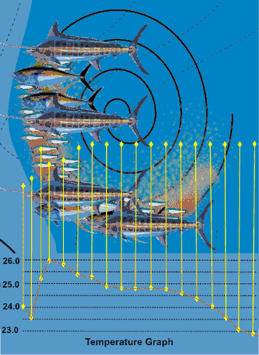
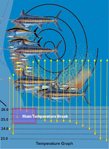
Often these currents are part of oceanic eddies. The structure of an eddy is not uniform. The current is fastest along its leading edge and weakens towards the back and centre. The highest concentrations of phytoplankton, algae and therefore the animals that feed on them and the rest of the chain of life is also most concentrated along the leading edge of the eddy as illustrated to the right.Everything fits into the picture as the temperature within the eddy. The leading edge is also where the major temperature changes or breaks are found as shown. Note that the larger predators do have a higher tolerance for temperature changes so a wide area may have to be explored to locate them.
By use of charts and wind direction, SST’s, reports etc we can have some idea of where to go, for example, a set of canyons or drop off or in reality anything that will disrupt the natural flow of currents, this includes tidal currents. But now it’s time to check the signs that indicate we are in the right area.
This is easy, basically, any sign is a good one. Any sign of life, or any water disruption. Current lines are easy to see on calm days, they are the smoother water highways that wind through the ocean. Often there is different coloured water on either side. The edges may be marked with weed lines or other flotsam gathered by wind and current along these highways. Even in the open ocean, any sized flotsam is worth investigating. Hopefully, there will be an associated temperature change. On rougher days the currents will cause areas to be rougher than others particularly on the edges of currents and over the structure including very deep formations. One often missed sign is coastal freighters that will run with the fastest current where the best temperature breaks are to save fuel and increase speed.
Other signs are birds, either sitting, gliding, hovering expectantly, the higher the bird is circling the deeper the fish are or hopefully working on breaking fish. Bait may be flicking on the surface or showing on the sounder.
Any form of life is a sign of a present food chain, although, certainly a school of fish smashing the surface feeding on bait is one of the best signs. In reality, a sign is anything at all that shows some difference in the water, i.e. wave motion, things floating, ripples, hovering birds, etc. Anything that differs from its surrounding is all signs worth noting. The ideal combination is a structure with the current hitting it, preferably the front or edge of an eddy with some signs. The more signs you can get in one place at the same time the better your chances will be.
![]()